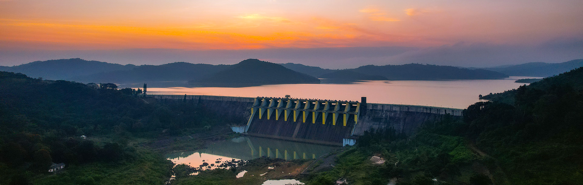
| Indravati (Kathiguda) H.E Project | |
|---|---|
| Hydrology | |
| Catchment Area | 2630 Sq. Km. |
| Maximum Annual Rainfall | 2345 mm |
| Minimum Annual Rainfall | 1138 mm |
| Mean Annual Rainfall | 1792 mm |
| Probable Maximum Flood | 23030 Cu.M./Sec. |
| Reservoir | |
| Full Reservoir Level | 642.00 M |
| Maximum Water Level | 643.00 M |
| Minimum Draw Down Level | 625.00 M |
| Live Storage | 1455.76 M.Cu.M. |
| Dead Storage | 851.94 M.Cu.M. |
| Gross Storage | 2307.70 M.Cu.M. |
| Water Spread Area at FRL | 110.00 Sq.Km. |
| P.M.F. Inflow | 27070 Cu.M. |
| DAMS : Indravati Dam (Masonry, Gravity Type) | |
| Latitude | 19° 16′ N |
| Longitude | 82° 50′ E |
| Catchment | 1153 Sq.Km. |
| Length Overall | 539 M |
| Length of Non-Overflow Sections | 410 M |
| Length of Spillway Including Piers | 129 M |
| Deepest Bed Level | R.L. 600 M |
| Dam Top Level | 645 M |
| Width | 7.5 M |
| Maximum Height of Dam | 45 M |
| Spillway Crest Level | 629.5 M |
| Radial Gate No. / Width × Height | 7 / 15.00 × 12.5 M |
| Capacity MWL EL 643 | 11,430 Cu.M./Sec. |
| Depletion Sluices No. / Width × Height | 4 / 2.00 × 3 m |
| Sill Level of Depletion Sluice | 610 m |
| Discharge EL 643 | 555 Cu.M./Sec. |
| Podagada Dam (Homogenous Earth Fill) | |
| Latitude | 19° 14′ N |
| Longitude | 82° 49′ E |
| Catchment | 389 Sq.Km. |
| Length Overall | 462 M |
| Deepest Bed Level | 570 M |
| Dam Top Level | 647 M |
| Top Width | 9.0 M |
| Parapet Height | 1.0 M |
| Maximum Height Above Bed Level | 77 M |
| Protection | Upstream: 0.6 m Riprap over 0.3 m Filter Downstream: Grass Turfing |
| Depletion Tunnel | |
| Number / Diameter | 1 / 6.2 M |
| Sill Level of Depletion Tunnel | 590 M |
| Discharge MRL 643 | 650 Cu.M./Sec. |
| Kapur Dam (Homogenous Earth Fill) | |
| Latitude | 19° 6′ N |
| Longitude | 82° 47′ E |
| Catchment | 60 Sq.Km. |
| Length Overall | 537 M |
| Deepest Bed Level | 582 M |
| Dam Top Level | 646 M |
| Top Width | 9.0 M |
| Parapet Height | 1.0 M |
| Maximum Height Above Bed Level | 64 M |
| Protection | Upstream: 0.6 M Riprap over 0.3 M Filter Downstream: Grass Turfing |
| Muran Dam (Masonry, Gravity Type) | |
| Latitude | 19° 6′ N |
| Longitude | 82° 46′ E |
| Catchment | 1028 Sq.Km. |
| Length Overall | 590.9 M |
| Length of Non-Overflow Section | 495.9 M |
| Length of Spillway Including Piers | 95 M |
| Deepest Bed Level | 580 M |
| Dam Crest Level | 645 M |
| Width | 7.5 M |
| Maximum Height Above Deepest Foundation | 65 M |
| Spillway Crest Level | 629.5 M |
| Radial Gates No. / Width / Height | 5 / 15.0 / 12.5 M |
| Capacity | 8,000 Cu.M./Sec. |
| Depletion Sluices No. / Width / Height | 4 / 1.5 × 4 M |
| Discharge MRL 643 | 588 Cu.M./Sec. |
| Sill Level of Depletion Sluice | 595.230 M |
| Location | |
| Latitude | N 19°0 05 ‘ to N 19° 25 ‘ |
| Longitude | E 82° 45 ‘ to 82° 55 ‘ |
| DYKES (Homogeneous Earth Fill) | |||
|---|---|---|---|
| Side | Dyke No. | Height (m) | Crest Length (m) |
| Left | 1 | 30 | 353 |
| – – | 2 | 20 | 320 |
| – – | 3 | 15 | 680 |
| – – | 4 | 20 | 160 |
| Right | 1 | 15 | 463 |
| – – | 2 | 20 | 146 |
| – – | 3 | 25 | 593 |
| – – | 4 | 15 | 535 |
| Crest Level | – – | 646 m | – – |
| Width | – – | 7.0 m | – – |
| Parapet Height | – – | 1.0 m | – – |
| Link Channels | ||
|---|---|---|
| Channel Name | Length (m) | Bed Elevation (m) |
| Guntrukhal | 1523 | 613.00 |
| Kusumpadar | 1550 | 620.0 |